


Picture a miniature version of a planned city like Peachtree City astride the new and controversial West Fayetteville Bypass in the middle of Fayette County.
Picture a thousand acres comprising six residential hamlets and neighborhoods, including parks and commercial areas in the rolling land around three sides of the Piedmont Fayette Hospital.
Picture a thousand acres left in its natural state as perpetual open space.
Now picture the westward envelopment of those 2,000 acres by the city of Fayetteville, some of which would be serviced by Fayetteville’s water and — most significantly — sewer system, and you’ve got a picture of the “West Fayetteville Neighborhoods,” the name of a plan jointly funded by the Fayette County Development Authority and the city of Fayetteville.
[To view the entire pdf package about West Fayetteville Neighborhoods, click on the file attachment link at the bottom of this story. CAUTION: The file is nearly 5 megabytes in size and may take a while to open or download.]
The FCDA paid for two-thirds of the $20,000 study, while Fayetteville paid the remaining one-third. The latest version of the plan document is dated May 26, 2010.
“To have such a large amount of property next to the hospital and to come up with a concept was the intent on the part of the development authority,” said FCDA President Brandt Herndon, adding the FCDA’s chief emphasis involves the areas adjacent to the hospital. “A master plan benefits everybody.”
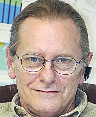
Fayetteville Mayor Ken Steele agreed, citing a geographical reality as the reason in 2008 to pay for a share of the concept study. The West Fayetteville Neighborhood and the Crystal Lake Neighborhood concept areas are adjacent to the city limits while Piedmont Fayette Hospital, positioned between the two, is situated in the city.
“It was prudent to check out all eventualities for the future. We want to have input in the way the community develops. It’s irresponsible not to look at what types of development people will be anticipating in the future,” Steele said.
Back in the days of the Highway 54 Task Force in 2006 there was the potential that some portions of the property represented in the concept plan might be annexed into the city and provided with sewer service. That potential still exists.
“We won’t annex speculatively and we won’t annex if it is not an overall plus for the city,” Steele said of the areas in the more immediate vicinity of the hospital, adding that any future expansion of the hospital complex would require sewer service. “Annexation of any property would be a joint decision should that time come in the future.”
And that is the current reality of the West Fayetteville Neighborhoods concept plan. Though it successfully cuts against the grain of standard residential and retail development, the reality is that any future that it might have is contingent on the marketplace.
How the plan started
The development future of the large area of land along Ga. Highway 54 north and west of Piedmont Fayette Hospital in central Fayette County has long been the subject of community speculation.
What began in late 2006 as a development collaborative effort called the Highway 54 Task Force to create a master plan to offset piecemeal development in the 2,000-acre area has evolved into a revised concept called the West Fayetteville Neighborhoods.
The concept plan spearheaded by Historical Concepts of Peachtree City shows approximately 1,000 acres of developable land and 1,000 acres of trees, ponds and wetlands left as open space.
The plan shows development clustered into six “neighborhoods” and “hamlets” that retain approximately 25 percent open space.
Commenting on the concept plan for the area north of Hwy. 54 and stretching from east of Sandy Creek Road to Tyrone Road, Historical Concepts partner Aaron Daily said this land has been held by several families for generations, including the majority stakeholders from the Rivers, Lester, and Horton families, which account for approximately 50 percent of the land.
The recent visioning process that led to the concept plan included large and small land owners, the Fayette County Development Authority (FCDA), the Fayetteville Planning Dept., Historical Concepts staff, Miami architect Jaime Correa, Piedmont Fayette Hospital and potential higher learning institutions.
“The general consensus was to create a cohesive planned neighborhood that can be enjoyed by everyone,” the conceptual study reported. The visioning team started with an analysis of the existing site conditions and a proposed program for the land. A three-day brainstorming session that followed included several sessions of sketches and feedback from the FCDA and Fayetteville representatives. The visioning team incorporated the input from these entities and major stakeholders into this conceptual vision, the concept study said.
Guidelines for the vision
Several objectives and principles were outlined to guide the creation of the concept plan that provides a unified vision incorporating residential, office, institutions of higher learning, hospital expansion, athletic facilities, retail, and civic entities while integrating and preserving the existing landscape into compact, walkable, safe, and sustainable communities, the study noted.
“This vision improves upon the haphazard conventional suburban planning and implements traditional town planning principles that remind us of the small towns and neighborhoods that our parents and grandparents have enjoyed for generations. Inherent in traditional town planning are several elements that create a sustainable community. By providing the community needs within a comfortable walk or golf cart ride, you reduce the number of vehicle miles traveled and thusly improve the air quality of the neighborhood,” the study said.
Daily said that city and county zoning maps covering the 2,000-acre area show that the majority of the land is held as residential with single-use districts for the institutions such as Piedmont Fayette Hospital, a high school site for the Fayette County Board of Education, churches and commercial centers that include office and retail. It is evident that there is no distinct center of the community, resulting in a disjointed plan, the study said.
So what might the West Fayetteville Neighborhoods plan look like if brought to fruition sometime in the future?
The neighborhood look
The 2,000-acre site is located among the rural land to the north, east and west of Piedmont Fayette Hospital off Hwy. 54 and is bordered by Sandy Creek Road and Tyrone Road. The project study area encompasses land in both unincorporated Fayette County and the city of Fayetteville.
The concept plan for the 2,000-acre area shows that approximately half the acreage is targeted development with the remaining 1,000 acres untouched. The undeveloped area contains 300 acres of wetlands.
As envisioned, the developed areas would be clustered into neighborhoods and hamlets. Within the developed areas the open space is projected to total approximately 25 percent. The swap-off for having half of the 2,000 acres left untouched means having a higher density of the developable acreage designated for residential, retail and civic use. The concept plan, however, does not address the specifics of residential and commercial development since those issues would be part of a multi-step process that would require new architectural and development guidelines, said Daily.
The West Fayetteville Neighborhood would be located along Hwy. 54 immediately to the north and west of Piedmont Fayette Hospital and is essentially the centerpiece of the overall concept plan. Totaling 170 acres, the development as conceived would include 34 acres of parks and open space, especially along the West Fayetteville Bypass, and the hospital complex at 54 acres.
The west portion of the West Fayetteville Neighborhood would feature a large brick-paved plaza surrounded by a mixed-use neighborhood center, a performing arts hall and a church. The concept plan also includes significant space for an expansion of the Piedmont Fayette Hospital campus.
The West Fayetteville Neighborhood, excluding the 54-acre hospital campus, would include 20 percent open space.
Meet the hamlets
The Rivers Hamlet represents the northernmost development within the 2,000 acres and would be situated on either side of Sandy Creek Road. The Rivers Hamlet totals 300 acres that includes 28 acres of parks, 61 acres of farmland, 8 acres for an orchard and 5 acres for a farmer’s market. As conceived, the Rivers Hamlet would include 32 percent open space.
The Trammell Hamlet would be situated in the northwest portion of the concept plan area and totals 135 acres that includes 37 acres of farmland, 10 acres as a solar farm and 5 acres of park land. The Trammell Hamlet would include 39 percent open space and could connect by a path or road to the Lester Hamlet to the south.
The Lester Hamlet would be situated along Hwy. 54 between the West Fayetteville Bypass and Tyrone Road. The Lester Hamlet totals 172 acres that includes 60 acres for a potential high school, 18 acres of parks and 4.5 acres of pasture along Ga. Highway 54. The Lester Hamlet, excluding the 60-acre high school campus, would include 21 percent open space.
The Crystal Lake Neighborhood located immediately to the east of Piedmont Fayette Hospital and extending across Sandy Creek Road to Crystal Lake totals 126 acres with 25 acres as parkland, including a park overlooking Crystal Lake. The Crystal Lake Neighborhood would include 20 percent open space. The areas to the east and west are situated inside the incorporated area of Fayetteville.
The Horton Hamlet located adjacent to the west side of the West Fayetteville Neighborhood across the bypass totals 80 acres that includes a 26-acre park. The Horton Hamlet would include 33 percent open space and could connect by path or roadway to the Trammell Hamlet.
Distinctive differences
It is noteworthy, the study said, that the conceptual plan builds on Fayetteville’s downtown by creating a mixed-use neighborhood surrounded by small hamlets rather than continuing the long-held conventional single-use approach that dots the development landscape with strip malls, monotype housing subdivisions and office parks.
“Conventional highway development typically pulls from and guts downtowns by spreading uses apart, then paying in time and money to connect them over longer distances. By growing through complete neighborhoods and hamlets, Fayetteville can reduce the amount of local auto-oriented traffic while creating a pedestrian friendly environment that adds to the character of the city. This more compact form of development allows the city to preserve and integrate the natural settings the citizens have grown to love,” the concept plan document said.
The idea of clustering residential, retail and civic development works in tandem with the overall concept plan.
Daily said smaller homes and lots use less surface area than the conventional suburban planning which allows the community to preserve the existing landscape and farmland.
Integrating working farms into the communities maintains the character and history of its origins as well as creates an instant sense of place with farmer’s markets. Artists markets, events, and festivals can take place in any number of open parks scattered throughout the plan.
Each hamlet and neighborhood was designed with the intent of preservation and sustainability in creating great places to live, work and play.
Remember small towns
“The connectivity established throughout this plan is reminiscent of the old small towns in Georgia,” the plan noted. “The network of streets provides multiple routes to the same destination and breaks up the larger super-blocks that impede pedestrian activity. Each street will have a sidewalk encouraging local residents and visiting friends to walk to the nearest restaurant or shop. Numerous multi-purpose pathways weave through the undisturbed landscape connecting the hamlets to each other and the neighborhood.”
As conceived, the concept plan shows that the development of the neighborhoods and hamlets are not solely dependent on the West Fayetteville Bypass since the West Fayetteville Neighborhood and the Lester Hamlet front along Hwy. 54 and the Crystal Lake Neighborhood and Rivers Hamlet front Sandy Creek Road.
The concept study noted that the preservation of the existing landscape was a key component in creating the neighborhood and hamlets. Each parcel weaves existing tree cover, dirt roads, and significant tree lines into the plotting of the streets, blocks, and lots.
This gave each hamlet a unique characteristic unto itself by forming to the landscape and mature trees into which the hamlets and neighborhood are given instant character and charm to the street, according to the FCDA document.
Narrow tree lined streets significantly decrease the surface temperature by shading and reducing the amount of pavement, which also increases the longevity of the infrastructure with less maintenance, says the FCDA document.
Permeable sidewalks and parking lots allow storm-water to naturally return to the ground and reduce the capacity of infrastructure needed for water run-off thus reducing costs and improving local water quality, the document says.
Looking back, looking forward
The history that led to the concept plan goes back a number of years. At that time and for decades, the owners of large tracts of property across Fayette County sold their land to developers who, in turn, built many of the county’s subdivisions and commercial venues. The large property owners holding the 2,000 acres in the vicinity of the hospital could have done the same, the FCDA document says.
Proposed as an alternative to the customary form of development the Highway 54 Task Force was formed in late 2006 and was populated by large land owners in the area, the FCDA, Fayetteville, Piedmont Fayette Hospital and the Fayette County School System.
“The city and the county are continuously being approached by developers,” said then-Fayette County Commission Chairman Greg Dunn in late 2006. “We don’t want small random developments, only to end up with 2,000 acres of one-half acre lots. We want an overall concept plan in place between the city and the county. We think we can accommodate each other by using a common sense approach. This will send a message to developers that shopping around for more density won’t work. And the planning for this will go on for years with the quality we’re expecting.”
The concept plan included the areas north of Hwy. 54 and east of Sandy Creek Road and extending to Tyrone Road on the west. The plan called for future development efforts to include large areas of residential north of Hwy. 54, medical and other office use in proximity to Hwy. 54, limited commercial at Hwy. 54 and Tyrone Road and a potential institute of higher learning in proximity to the hospital and the proposed high school northeast of the Tyrone Road/Hwy. 54 intersection.
Residential density of one unit per 1-2 acres was forecast if the area remained in the unincorporated county. Density would potentially be reduced to one unit per half-acre if the area was eventually annexed into Fayetteville.
The northernmost area of the early concept plan, situated north and west of the Sandy Creek basin, would maintain a residential density of one unit per 2-3 acres, the plan said. No annexation was anticipated in this area.
The plan limited the amount of commercial development to the area to approximately 20 acres on the northeast corner of Hwy. 54 and Tyrone Road. The plan recommended a neighborhood shopping center to serve the immediate residential area. Plans recommended a grocery store anchor with a total shopping center maximum of 150,000 square feet of retail and the anchor store of no more than 56,000 square feet.
The intent was to limit the amount and type of commercial development so that it neither becomes a regional shopping destination nor competes with the commercial development in Fayetteville and Peachtree City, planners said.
The original concept plan also suggested the evaluation of an internal connecting road system within the study area to avoid increased traffic congestion on Hwy. 54. The internal road system could include the proposed West Fayetteville Bypass, a road from Tyrone Road to the West Fayetteville Bypass with connection to Huiet Road.
The Fayetteville City Council in January 2007 followed the Fayette County Commission and signed off on the concept plan.
It was nearly two years later in late 2008 that Historical Concepts entered the process and began meeting with essentially the same group to eventually arrive at the current concept.
Leave a Comment
You must be logged in to post a comment.